
At first glance, the windblown sandstone landscape of the Bisti/De-Na-Zin Wilderness looks like the most desolate place on Earth, an inhospitable expanse of sky, sand, and oddly shaped rock formations called hoodoos.
But millions of years ago, these badlands, in what’s now northern New Mexico, were a coastal swamp in an inland sea, alive with large trees, reptiles, primitive mammals, and meat-chomping dinosaurs.
The Navajo (Diné)—whose lands intersect and border these 41,170 protected acres—gave the area its dual names: Bisti, meaning a “large area of shale hills,” and De-Na-Zin, from the word for “standing cranes. ” The high desert plains surrounding the Bisti/De-Na-Zin are about 6,500 feet above sea level, though the badlands themselves sit 200 to 400 feet below that due to erosion.
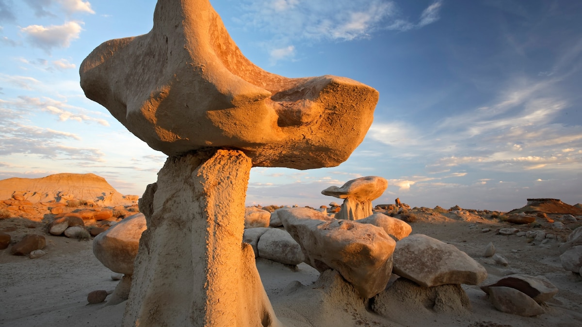
Hikers will find many winged sandstone rock formations in the Bisti/De-Na-Zin Wilderness in northern New Mexico.
Photograph by Colin D. Young, Alamy Stock
Please be respectful of copyright. Unauthorized use is prohibited.
To the Navajo and other Indigenous people, these lands served as a seasonal migration path, sacred grounds, and even a playground of sorts. “My cousins and I would come out here and camp and explore,” says Kialo Winters, founder of Navajo Tours USA, which leads guided trips through the wilderness. “It was a great place for hide-and-go-seek.”
It took millennia for lush wetlands to turn into these otherworldly high desert badlands, where eroded sandstone features can resemble mushrooms, towering chess pieces, or even fried eggs. Here’s how they were formed, what to look for, and how to explore this delicate region without damaging it.
A fertile, ‘beast’-filled past
Millions of years of erosion formed Bisti/De-Na-Zin Wilderness (Bisti is pronounced bis-tie) in this corner of the San Juan Basin. Once covered in swamps and deltas of the Western Interior Seaway, the area was filled with sediments and organic materials in prehistoric times. At some point, a volcanic eruption blanketed everything in ash. As the sea began to recede about 50 million years ago, dinosaurs, reptiles, and other animals thrived in the wetlands along the resulting riverbeds.
Eventually, the water disappeared entirely, leaving behind embedded layers of sandstone, mudstone, shale, and coal, which were all uplifted with the Colorado Plateau starting around 6,000 years ago. Shortly after that, the last ice age receded, and the waters of its melting glaciers carved away the rock. This formed its distinctive hoodoos and exposed Bisti’s wealth of fossils and petrified wood.
“We know from fossil plants and woods that this was once a jungle with lots of dinosaurs,” professor Spencer Lucas, curator of paleontology at the New Mexico Museum of Natural History and Science in Albuquerque. “When animals died here, they would have quickly been buried in sand and mud that preserved them.”

The “Bisti Beast,” a 70-million-year-old fossil skull of a species of tyrannosaur, was discovered in the Bisti/De-Na-Zin Wilderness. It is now on display at the New Mexico Museum of Natural History and Science in Albuquerque.
Photograph by Marla Brose, Albuquerque Journal/ZUMA Wire/Alamy Stock Photo
Please be respectful of copyright. Unauthorized use is prohibited.
Scientists have discovered and excavated numerous fossils here in the protected wilderness, which is overseen by the Bureau of Land Management, an agency of the US Department of the Interior responsible for safeguarding pristine natural areas set aside by the government.
(Looking for indigenous connections in South Dakota’s badlands.)
The animals that once roamed these lands include duckbill dinosaurs, ancient turtles, and the “Bisti Beast.” The last, found by a volunteer in 1997, is a 29-foot-long (9-meter-long) “destroyer” dinosaur, a primitive relative of the T. rex. Now on display at the New Mexico Museum of Natural History and Science in Albuquerque, Bistahieversor sealeyi was eventually ruled an entirely new species.
Exploring the badlands
While scientists might come to Bisti to dig for dinos, travelers are lured by the area’s rock formations, those undulating, seemingly abstract forms that create a landscape that resembles both the surface of the moon and a Looney Tunes Wild West backdrop. They’re catnip for nature photographers toting tripods or smartphones.
Shaped by wind and erosion, these spires and hoodoos range from a few feet tall to two stories high. (The term “hoodoo” may come from the Caribbean African “voodoo,” a nod to the formations’ bewitching shapes.)
Please be respectful of copyright. Unauthorized use is prohibited.
Please be respectful of copyright. Unauthorized use is prohibited.
Left: Nicknamed the “cracked eggs,” these stone formations in the Bisti/De-Na-Zin Wilderness are popular with photographers.
Photograph by Design Pics Inc., Alamy Stock
Right: A winged hoodoo in the Bisti/De-Na-Zin badlands was formed by millions of years of erosion.
Photograph by Jeremy Woodhouse, Getty Images
Some hoodoos are winglike; others resemble hatching eggs. “The erosional features are quite amazing, like natural art forms,” says Lucas. They can be found around “washes”—remnants of those ancient riverbeds—beginning about a mile hike in from either of the two access points to the wilderness area. Both entrances are located less than an hour’s drive south of Farmington, New Mexico, or an hour-and-a-half drive south of Durango, Colorado.
Due to the delicate nature of the ground and potential damage to the hoodoos, the Bisti/De-Na-Zin Wilderness can only be explored on foot or horseback.
“Be mindful to step only on firm ground,” says Winters. “The softer ‘feathered’ ground near the bases of hoodoos represents ongoing natural erosion, and you don’t want to disturb their balance.” Besides keeping your distance from the ground near hoodoos, it’s imperative not to touch them or other ancient fossils like petrified wood or shells.
While dinosaurs haven’t roamed here for about 65 million years, these badlands are surprisingly rich in wildlife, especially birds. You can spot golden eagles, towhees, and ravens in the stark desert skies or jackrabbits and cottontails amid the sand and scrub grass. At night, campers might see coyotes or, more rarely, a giant desert centipede (Scolopendra heros) which can grow up to eight inches long.
The vastness of this wilderness and the no-wheeled-vehicle rule means hikers, horseback riders, and primitive campers often have this BLM land nearly to themselves. There are no marked hiking paths from either of the entrance points to the wilderness, meaning visitors experience nature in a more freeform, less-managed way.
(Why Indigenous symbols are replacing colonial monuments in New Mexico.)
Unfortunately, that also means it’s easy to get lost. Some navigational skills or a guide can help in areas where phone signals are scarce. When exploring here, BLM recommends using a smartphone app or GPS device with a topographic map loaded ahead of your visit.
It’s a good idea to pack a backup of either paper maps and a compass or a second smartphone with maps loaded. BLM New Mexico has created hunting/recreation maps that can be downloaded and used with the free CarryMap App. Topographic maps can also be downloaded.
The high altitude of these desert plains means summer days can be hot and winter nights cold (and sometimes, snowy). This makes spring and fall ideal times to visit, and sunblock, sun hats, and lots of water necessary no matter the season.
Jennifer Barger is a senior travel editor at National Geographic. Follow her on Instagram.
Comments are closed.